MFMC(41)
·
Item
·
n.d.
Part of Miscellaneous folded map collection
Maps and atlases
485 Archival description results for Maps and atlases
465 results directly related
Exclude narrower terms
87-001/MC12(02)
·
Item
·
1775
Part of Robert Lloyd Hunter collection
87-001/HMC12
·
Item
·
1808
Part of Robert Lloyd Hunter collection
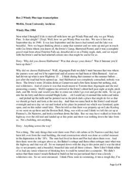
90-016
·
Fonds
·
1882-1989
This addition to the fonds consists of personal and career-related materials of Mary L. Northway such as cassettes with interviews, family wills, photographs and slides, an honorary doctorate from Trent University, correspondence and documents regarding the transfer of deed of Windy Pine property to Trent University, materials relating to camping and to Nominigan as well as copies of Mary Northway's publications. There are also business-related photographs, correspondence, etc. of John Northway, Mary Northway's grandfather. One file of papers regarding the Neathern Trust was added in 1992.
Northway family
MFMC(07)
·
Item
·
1978
Part of Miscellaneous folded map collection
87-001/HMC19
·
Item
·
[1740?]
Part of Robert Lloyd Hunter collection
87-001/MC11(01)
·
Item
·
1705
Part of Robert Lloyd Hunter collection
87-001/MC12(01)
·
Item
·
1719
Part of Robert Lloyd Hunter collection
Chatelain's map of North America was published to promote the interests of the Compagnie Francoise Occident, a trading company established to encourage the development of the Louisiana territory and as a consequence of its development, the stabilization of a lagging French economy. The map illustrates the relationship among the French, English and Spanish claims on the continent.
87-001/HMC14
·
Item
·
1747
Part of Robert Lloyd Hunter collection
87-001/HMC18
·
Item
·
1688
Part of Robert Lloyd Hunter collection
87-001/HMC04.5
·
Item
·
1755
Part of Robert Lloyd Hunter collection
87-001/HMC22
·
Item
·
1851
Part of Robert Lloyd Hunter collection
87-001/MC11(16)
·
Item
·
[1674?]
Part of Robert Lloyd Hunter collection
87-001/MC11(17)
·
Item
·
1833
Part of Robert Lloyd Hunter collection
90-012
·
Fonds
·
1962-1979
This fonds consists of Norman Townsend's original research material, including extensive field notes, of the Pokomo people of Tana Irrigation Scheme, Kenya; research papers by Norman Townsend (& others); university course outlines & lecture material; bibliographies; correspondence with researchers, universities, and the Canada Council, etc. as well as maps, especially of Africa.
Townsend, Norman
90-013
·
Fonds
·
1957-1988
This addition to the fonds consists of interviews with prominent NDP and labour activists recalling the 1960 by-election in Peterborough, and the early history of the Co-operative Commonwealth Federation (CCF) and the New Democratic Party (NDP) in the riding. As well there are related transcripts; newspaper articles and correspondence.
New Democratic Party
3
·
Series
·
1960 - 1994
Part of Douglas Sadler fonds. 1995 additions
Series consists of records documenting Sadler's involvement in various naturalist and environmental initiatives with businesses, government bodies, and other organizations. Records document The Outdoorsman Magazine, Campbell Productions documentary films, the Design Canada Education Seminar and Workshop Program, the Ontario Department of Lands and Forests, the Provincial Wayside (Roadside) Conference (sponsored by the Otonabee Region Conservation Authority (ORCA) and The Federation of Ontario Naturalists) in Peterborough in 1965. Series also includes significant documentation on the Peterborough City/County Waste Management Study. Sadler was the chairman of the Public Liaison Committee that assisted with communication between the public and the Waste Management Steering Committee.
98-004
·
Fonds
·
1968-1985
This fonds consists of the administrative records of the National and Provincial Parks Association of Canada (NPPAC), as well as correspondence, reports, and newsletters. Also included are materials relating to various national parks in Canada.
National and Provincial Parks Association of Canada
86-002
·
Fonds
·
1952-1978
This fonds consists of personnel files, general correspondence, financial records and publication materials all relating to the National and Provincial Parks of Canada. This includes many files on environmental concerns and the involvement of the Association.
National and Provincial Parks Association of Canada
23-016/OS1(01)
·
File
·
[197-]
Part of Lightbody family fonds